
Olympic Peninsula


Choose Your Own Adventure: A trip to the Olympic Peninsula
So many choices when it comes to camp sites, hikes, and vistas. I could probably spend months just hopping around the peninsula and still not get to do or see everything on my list. Whether you're backpacking or glamping, it's an amazing place to visit. I've only done a handful of hikes, and camped at one campground so far, but I'll definitely be going back to see more. During my process of searching the internet for the best places to visit within two days, there was an endless amount of information.
The National Park Service website was incredibly helpful, as well as blog posts and personal accounts of what others did in the Olympic Forest. While I normally search the Outbound (like all trails but with better photos) for the most photogenic and worthwhile hikes, there haven't been many submitted from the Peninsula yet. The blog posts I found via Pinterest were typically along the lines of "our Olympic Peninsula Itinerary!" which were helpful when trying to decide the best campground and areas to visit by comparison. But as someone who aspires to do literally everything in this park, I kept feeling like I needed more information than what was out there.
Tips and Tricks
Download the REI offline trail map app on your phone to get the most hikes out of this, and to be sure you don't pass up on seeing any gems along the way. It's totally free, and color coded by difficulty. People submit photos and information about each site, there are still quite a few that need to be adopted but still overall a great tool to have along the way.
Check campground status before heading out. It's not unusual for campsites or roads to campsites to close temporarily.
Each area of the park has it's own PDF brochure, follow the link to see them all. I'll also link to them throughout this post. I was able to download a few of them to keep in my ibooks app to access whenever I needed them. Each brochure has a trail map with a list of the trails elevation and length.
For driving direction you can do it the old fashioned way with a map, which isn't too difficult since there are just a few main highways. I had cell service for the majority of the time I was on 101. You can also download an offline map from the google maps app. It does take up some space in your phone, but it's nice to have because it can still route places from your current location.
Beginning the Journey
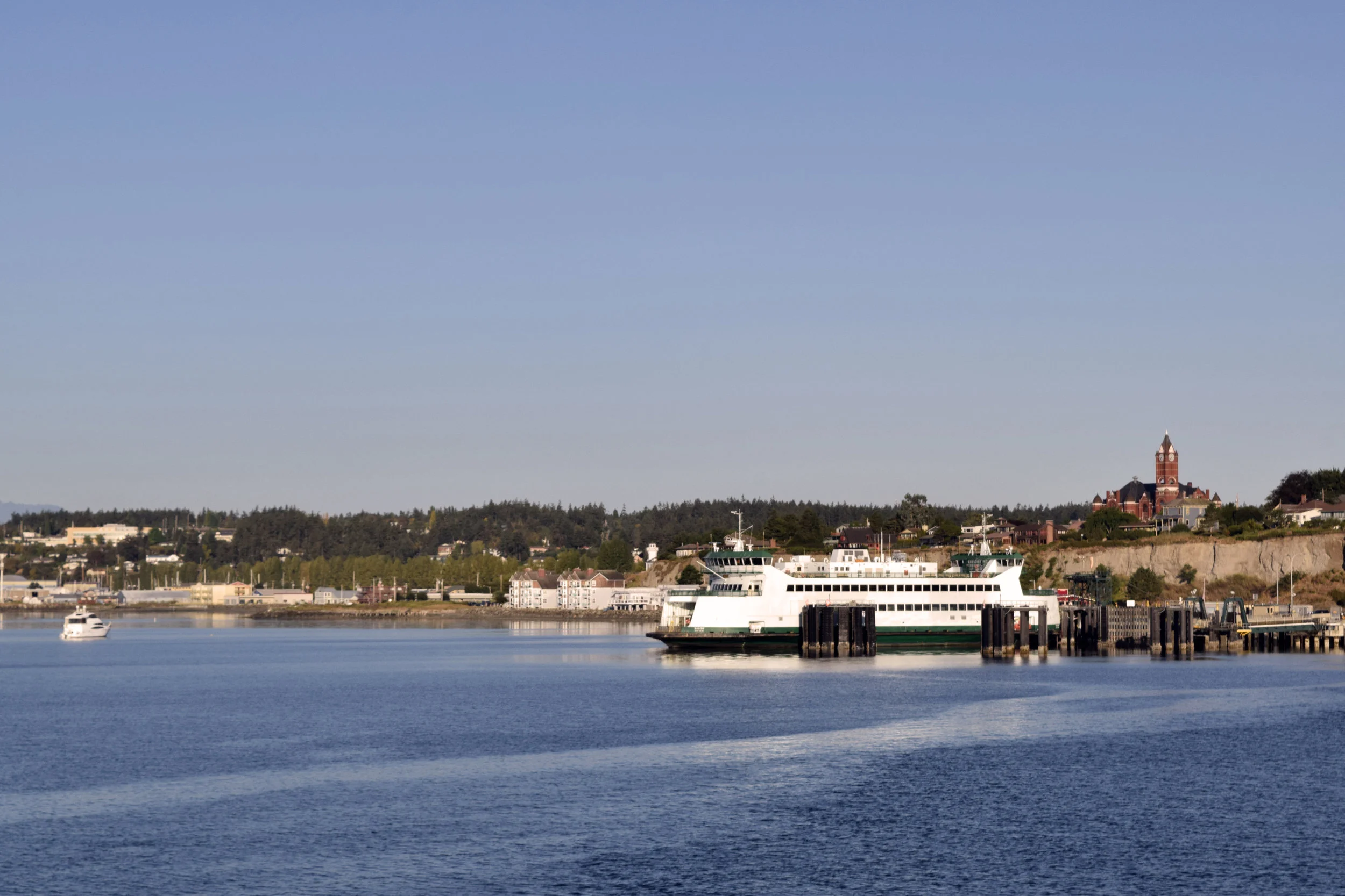
When getting to the Olympic Peninsula (from Seattle) there are a few choices. So many ferries to choose from! If you're avoiding the ferry life another option is to take the bridge in Tacoma. It's a long drive but it will still take less time than any ferry, and don't doubt that bridge views will be just as spectacular as those from the ferry boats, especially as the sun sets.
For this Adventure we made a stop on Whidbey Island so we could get an early start on the day. I reserved a spot on the earliest ferry from Coupeville to Port Townsend which left at 7:15, with a suggested 30 minute early arrival time. SO bright eyed and bushy tailed the driving began. This itinerary put us in the North East side of the park, an hour and a half drive from hurricane ridge.

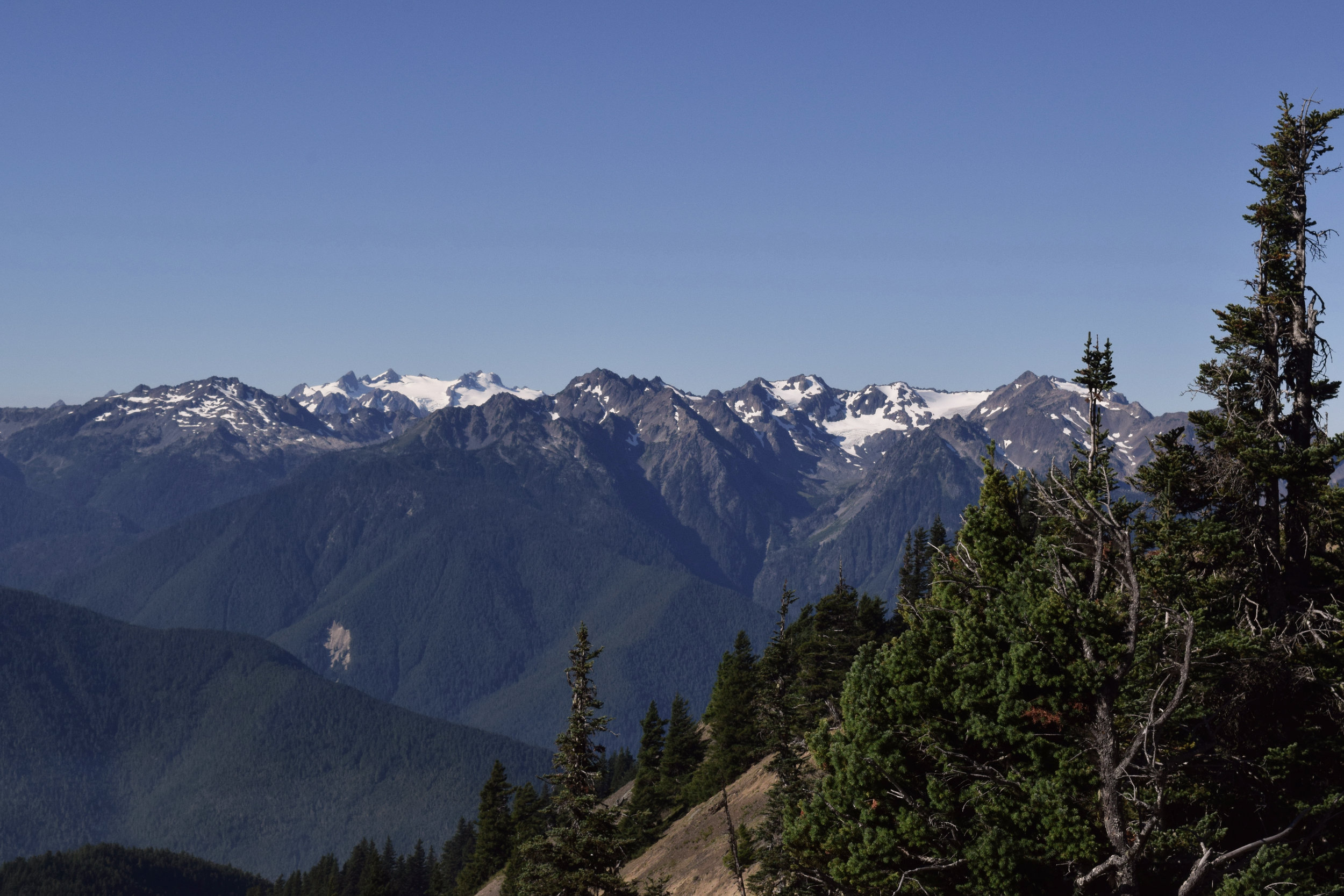
fire burning through the valleys right now as seen from Hurricane Hill. Smoky, but made for a beautiful Sunset in Seattle the last few nights.
Hurricane Ridge
Hurricane Ridge and I haven't always been on good terms. I love that they have a huge glorious ranger station, gift shop included, with real bathrooms. The views are spectacular, even when it's cloudy the mountains peek up and through the haze. It can get over crowded, quickly too. There are several hikes to choose from, many are completely or mostly paved and fairly short. For those seeking the unpaved trails to take up most the day it can get a little trickier, since after driving all that way up hill, you'd have to hike your way down. I haven't done the longer hikes but next time I find myself in the area I'm not leaving without making my way down to Whiskey Bend. Then from there maybe hiking the 26.7 mile trail along the Elwha River, and then the 20 mile long Skyline Ridge Trail. Like I said, It will take a long time before I do everything in this park that I would like.

Camp Life
There is a Campground near Hurricane Ridge as well, if you'd like to extend your stay here. It's at the bottom of the winding road, just after you pay the entrance fee. Heart of the Hills has 105 sites and is in the old growth forest, not one of the most spectacular campgrounds when it comes to views, but it gets the job done. If you're up for more driving, and a steeper cliff please try Deer Park campground. We didn't just because of limited time and a need to make it to Neah Bay the next morning. Deer Park has 14 campsites, and it is first come first serve. To get there it's a winding uphill climb, no trailers or RVs permitted. There are even more trails to explore there, so if you do get in super early to reserve a spot, there will be plenty to do while you're there.
Camping Equipment I Loved
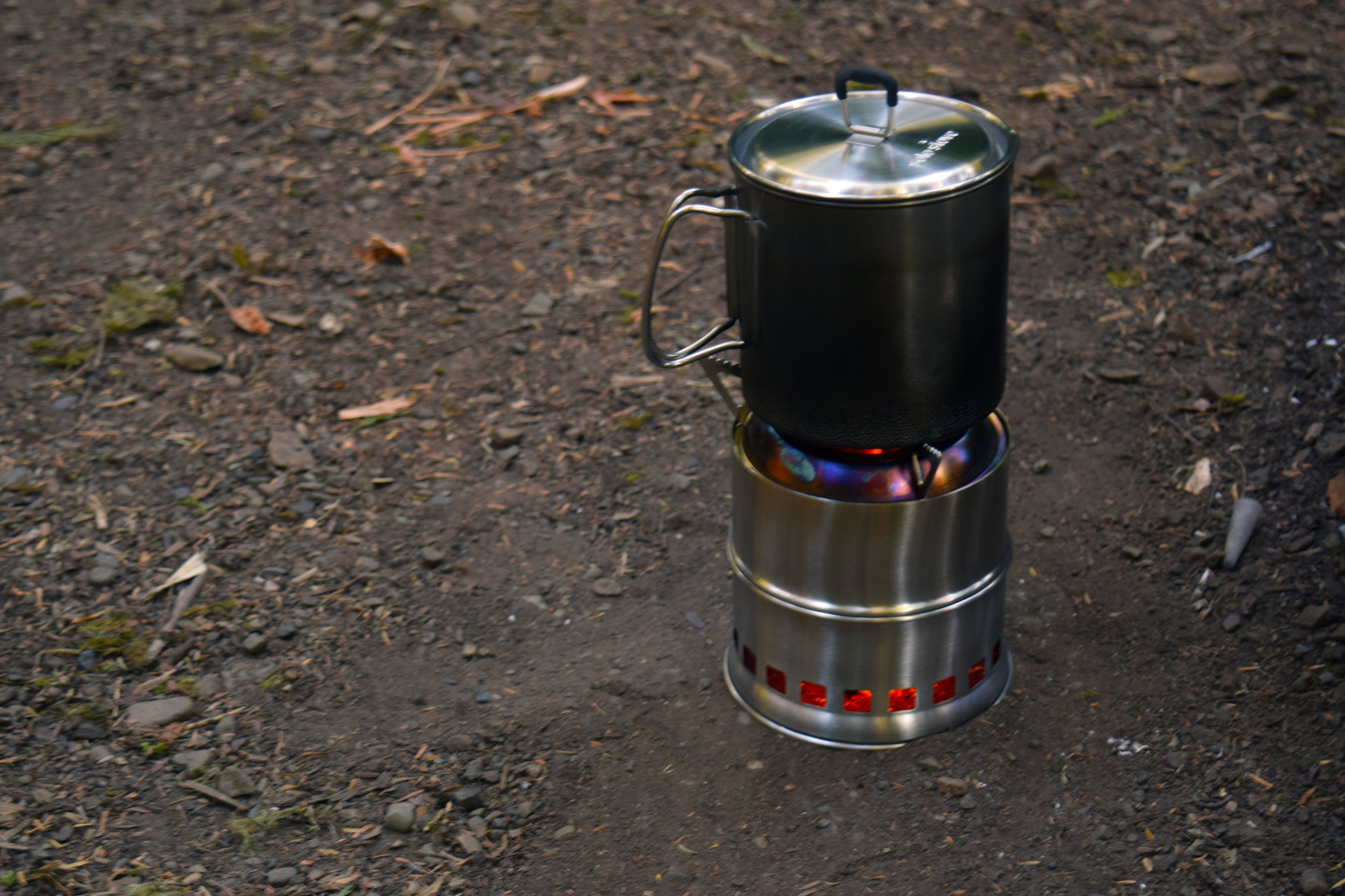
My wood burning stove actually boiled water! Fast too! I'll admit I was super skeptical at first. The only fuel I used was twigs I found in front of my tent.

Get a luminoodle! It's a noodle that just plugs into a USB battery. You can hang it in your tent or even wear it on your backpack.

Fairholme Campground & Lake Crescent
From Hurricane Ridge we made our way to Fairholme Campground, located right on Lake Crescent. It was about a two hour drive after some traffic due to road construction. The lake is gorgeous, bright blue and incredibly clear. It felt like we drove around the lake forever before finally spotting the sign for the campground. We were lucky enough to find a spot! The campground host let us know that it had been completely filled every day since July 4th. There are 88 spots available on the site. You have to walk into the ones closest to the lake, but at the others you can park your car or RV right in the site. We stayed in loop B, which was in the middle of the campground. I read before hand that some people had issues with the road noise from trucks driving by, but that wasn't an issue in our site.
In that same area there are a few other campgrounds, Sol Duc being one of the closest and one of the only two in the park that take reservations. When I checked online reservations were available about two weeks out, it would be convenient though if you were getting a later start on the day, because like I said, Fairholme really does fill up.


A big thank you to Katie and Hilary! My adventure pals in this camping adventure through the Olympic Peninsula. Find out more about this trip on their amazing blogs Seek The Welfare and Spunky Lovely. They're great travel/photography buddies and camping experts.

Hike to your hearts content
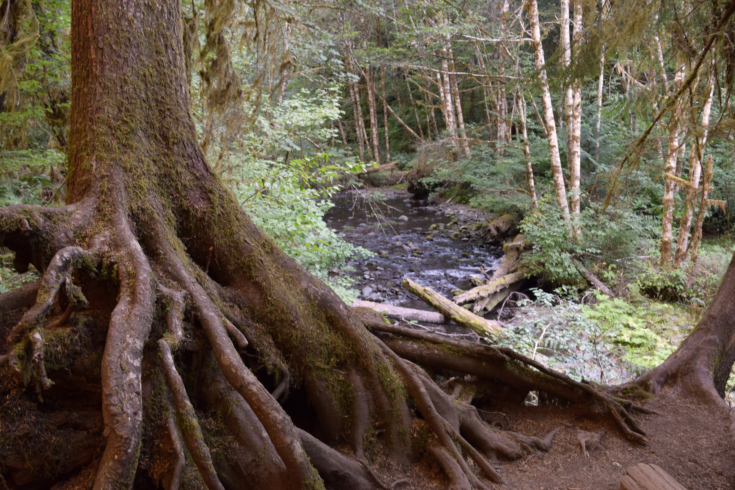
After checking into Fairholme we pitched our tents then set out to find more sites. Piling back in the car we back tracked a few miles to the ranger station off of 101, that was also the trail head to Marymere falls. The hike is short , 1.6 miles round trip, but if you're feeling more adventurous there are two more hikes that branch off from that trail. Barnes Creek trail goes through an old growth forest and wins the elevation award in this area, at 4,200 feet. It's an out and back trail, a 7.5 miles one way. There's also a sign for Mt. Storm King which is switch backs up the hill, 2.2 miles long.
There are two hikes that made this area specifically appealing to me. The Spruce Railroad Trail and Pyramind peak trail. The Spruce railroad trail is long and fairly flat, 4 miles one way, with the option of extending it to up to 15 miles. Pyramid peak is the opposite, 2 mile upward climb to a WWII spotting tower that looks over the lake.


Shi Shi Beach
From Fairholme it was about an hour and forty minute drive to the shi shi beach trail head. We left at 10 am, to be sure to get there at low tide which was 12:45 that day. The drive winds along the coast until you reach Neah Bay. We were lucky enough to have a rare clear day so we could see Canada as we drove. The parking lot at the trailhead was nearly full when we arrived, around 11:30 AM.
It's mostly flat 2 mile hike to the beach, with a steep climb down to the beach. From there you can extend the hike to the point of arches, another 6 miles down the beach. It would be amazing to camp here, especially on a clear night. We didn't see many campers there while we were on the beach, but a few more making their way down once we got back to the parking lot.